Egypt Neighbouring Countries and Regional Insights
Bordering Nations of Egypt
Egypt’s borders connect it with a bunch of countries, giving it a key spot on the political and geographical map. Let’s take a look at the countries that share land with Egypt: over to the west, down south, and up northeast.
Countries on the West
Libya cozies up to Egypt on the west side, with a stretch of about 1,115 kilometers (693 miles) between them. The Libya-Egypt connection is about more than just where the land ends; there’s a whole mix of politics and caution tied up in their relationship, especially with Libya’s ongoing internal roller coaster.
| Border Direction | Country | Length (km) |
|---|---|---|
| West | Libya | 1,115 |
Southern Border Nations
Heading south, you’ll bump into Sudan. They’ve got a hefty border of approximately 1,276 kilometers (793 miles). There’s some serious territory drama here, with spots like the Hala’ib Triangle stirring up a fuss between the two since Sudan became its own thing in ’56. They’re trying to play nice post-2011 uprising in Egypt, but trust issues are still a thing.
| Border Direction | Country | Length (km) |
|---|---|---|
| South | Sudan | 1,276 |
Neighbors to the Northeast
Up northeast, Egypt rubs shoulders with Israel and the Gaza Strip of the Palestinian Territories. The line with Israel is the runt at around 208 kilometers (129 miles). Over by Gaza, things get dicey thanks to security issues, pushing Egypt to put up a big steel wall to curb the sneaky smuggling of all kinds of stuff.
| Border Direction | Country or Territory | Length (km) |
|---|---|---|
| Northeast | Israel | 208 |
| Northeast | Gaza Strip | Varies |
Egypt’s neighbors aren’t just lines on a map; they shape the country’s security, politics, and everyday business. Dive into more neighborhood chatter with our take on Ethiopia’s neighbors and Eritrea’s neighbors.
The Halaib Triangle Dispute
Tucked between Egypt and Sudan, the Halaib Triangle’s a hotbed of claims and disputes, quite the geopolitical stew. For decades, these nations have squabbled over rightful ownership and conflicting border lines. Here, we’ll lay out the territorial tug-of-war and diplomatic drama surrounding this patch of land.
Sovereignty Claims
The Halaib Triangle is perched between the Red Sea and the 22nd latitude degree, acting as a bone of contention for Egypt and Sudan since Sudan cut its colonial ties in 1956, leading to dual ownership claims.
Historical Context:
| Year | Event |
|---|---|
| 1899 | That year marked the Anglo-Egyptian Condominium Agreement, drawing the border at the 22nd parallel. |
| 1902 | Bureaucrats decided that Sudan should run the Halaib Triangle since it would be a breeze administratively. |
| 1956 | As Sudan became its own nation, a territorial spat kicked off over the Halaib Triangle. |
Egypt’s been pretty proactive in showing who’s boss, like when they lit up Alshalateen with electricity back in 2009, making sure their presence was felt.
International Negotiations
Attempts to resolve the dispute through diplomacy often hit a wall thanks to the stubborn stances held by both countries.
-
Egypt’s Stand: Egypt isn’t interested in getting global referees involved or hashing it out over a mediation table. They insist the area has always been under their jurisdiction and have run it accordingly since making their claim official.
-
Sudan’s Push: Sudan, on the other hand, keeps waving the flag for a solution involving international law and arbitration. Yet, Egypt doesn’t budge, leaving Sudan’s pleas to fall flat.
| Year | Event |
|---|---|
| 1998 | Egypt and Sudan played nice, shaking hands on cooperative endeavors for the Halaib puzzle. |
| 2000 | Sudan pulled back its troops, tipping the scales in Egypt’s favor in the Halaib Triangle. |
| 2019 | Sudan went back to the arbitration call, but Egypt gave them the cold shoulder. |
While every now and then the two nations appear to buddy up over the Halaib Triangle, making headway still seems like a pipe dream. For those interested in nearby territories and tensions, our articles on Libya, Israel, and other regional matters are up for grabs.
Nile River Border
The Nile River stands out as an iconic feature, shaping Egypt’s past and present by serving as both a natural divider and lifeline.
Natural Boundary to Nubia
Long ago, the Nile drew a clear line between Egypt and Nubia. With Nubia nestled to the south, both regions found the river to be more than just a water source—it was the backbone of their survival. This watery line brought them together, not only through trade but also by blending their cultures. As they mingled, the Nile carried merchants, goods, and ideas along its length, helping each civilization bloom in its own unique way.
Division into Upper and Lower Egypt
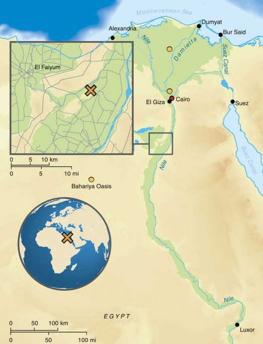
Egypt splits into two parts: Upper and Lower Egypt. In the north, Lower Egypt fans out across the Nile Delta, while Upper Egypt stretches southwards.
| Region | Key Features |
|---|---|
| Upper Egypt | Southern stretch, upriver from Nile |
| Lower Egypt | Northern expanse, includes Nile Delta |
The Delta up north has been a buzzing marketplace and a stage for historical dramas, forming a rich, fertile landscape perfect for farming and feeding its people. Its spot by the Mediterranean Sea opened doors to trade with far-off lands, weaving tales of cultural contact and commerce through the ages.
Meanwhile, Upper Egypt, tucked between two vast deserts, has been a cradle for ancient civilization. The Nile coursed through, nurturing settlements and fostering a wealth of cultural treasures that continue to echo through history.
All in all, the Nile isn’t just a river; it’s a lifeline and a separator that has etched Egypt’s narrative into the sands of time. It’s this tapestry of history—rich and diverse—that paints the true picture of Egypt’s heart and its evolution (Carnegie Museum of Natural History).
Importance of the Delta Region
The Delta region in Egypt is more than just a spot on a map; it’s like the motherboard of the country’s historical and economic circuits. Let’s chat about why it’s such an essential pit stop for trade and a key player in history.
Trade Hub
Think of the Delta as Egypt’s ancient business district, buzzing with trade and international mingling. Wedged right by the Mediterranean and the doorstep to the Levant, it’s been the perfect spot for wheelin’ and dealin’ since way back (Carnegie Museum of Natural History). With a chunky 620 miles (or about 1,000 km) of sea-kissed coastline (Britannica), it’s been a sailor’s dream – a launchpad for boats carrying everything from grains to exotic spices.
| Feature | Details |
|---|---|
| Coastline Length | About 620 miles (1,000 km) |
| Location | Beside the Mediterranean |
| Primary Trade Advantage | Close to Levant and Mediterranean routes |
Good soil and better weather mean the Delta’s fields are goldmines for agriculture, feeding Egypt and keeping economic wheels turning. It’s the place where most of the food magic happens – a huge chunk of Egypt’s grub grows right here.
Historical Significance
Historically speaking, the Delta region isn’t just important – it’s like the grandparent in a family who tells all the stories of old. Back in the days of Ancient Egypt, the Delta was one of the big four regions, hanging out with the Western Desert, Eastern Desert, and the famous Nile Valley. Its lush lands and prime spot made it ground zero for Egyptian civilization’s growth.
| Region | Role in Ancient Egypt |
|---|---|
| Delta | Food basket and trade gate |
| Nile Valley | The cultural and leadership hub |
| Western Desert | Treasure trove of minerals and bling |
| Eastern Desert | Route for trades and mining ops |
The Delta didn’t just control the land; it shaped Egypt’s old-school politics and power plays. It was the core of Lower Egypt, and when it combined forces with Upper Egypt from the south, they built a powerhouse of a nation. Archaeologists and historians can’t stop finding new gems from here that underline its past power and wealth.
For more on nearby hotspots, hop over to our pages on ecuador neighboring countries and eritrea neighboring countries.
Getting clued-up on the Delta’s current and past roles helps you see why it matters like a limited-edition trophy in Egypt’s collection. This patch of land is a bridge connecting Egypt to the Mediterranean vibe and further afield.
Management of Nile Water Resources
Figuring out the best way to handle Nile water resources is a priority for Egypt and the surrounding nations. They deal with group efforts like the Nile Basin Initiative and challenges brought on by the Grand Ethiopian Renaissance Dam.
Nile Basin Initiative
Started in 1999, the Nile Basin Initiative (NBI) aims to encourage collaboration and smart handling of Nile River resources among its 11 country members (National Geographic). This group faces a few big tasks, such as:
- Water Sharing: a fair divide of the Nile’s waters among the countries in the region.
- Environmental Protection: keeping the river’s ecosystem healthy and thriving.
- Economic Development: promoting growth-friendly activities without messing up the river’s condition.
Here’s how each of the 11 members fits into the NBI picture:
| Country | Role in NBI |
|---|---|
| Egypt | Big player, relying heavily on the Nile for water |
| Sudan | Major consumer of Nile water |
| Ethiopia | Home to the Blue Nile and the Renaissance Dam |
| Uganda | White Nile starts here |
| Kenya | Has downstream spots in the basin |
| Tanzania | Relies on the river as a water source |
| Rwanda | Upstream part of the White Nile |
| Burundi | Source of the Kagera River, a tributary |
| DR Congo | Minor role with some upstream bits |
| Eritrea | Checks things out from the sidelines |
| South Sudan | The newest member, lies along the White Nile |
Impact of Grand Ethiopian Renaissance Dam
The Grand Ethiopian Renaissance Dam (GERD) along the Blue Nile sparks both teamwork and tension between Egypt, Sudan, and Ethiopia. Here’s what to know:
Agreements and Tensions:
- Egypt, Sudan, and Ethiopia inked deals to manage how the dam’s built and used, hoping for collaborative fixes (National Geographic).
- Even so, worries linger about how it might mess with water flow for Egypt and Sudan.
Water Shortage Worries:
- Come 2025, Egypt might hit a water squeeze, making teaming up on the Nile even more critical (National Geographic).
- Egypt’s growing population ramps up demands on the river’s supply.
| Aspect | What it Means for Egypt | What it Means for Sudan | What it Means for Ethiopia |
|---|---|---|---|
| Water Availability | Water flow may take a hit | Impacts vary by deal terms | Better water storage and energy |
| Agricultural Impact | Irrigation and food risk | Relies on water handling | More agricultural possibilities |
| Energy Production | Stays the same | Might see benefits | Huge hydroelectric power leap |
For more on nearby countries and how they connect, check out these articles: ethiopia neighbouring countries, erdan neighbouring countries, or libya neighbouring countries.
Good stewardship of the Nile’s resources, along with careful consideration of how the GERD affects things, is key to stabilizing water supplies and boosting cooperation among Egypt and its neighbors.
Security Concerns Along Borders
Border with Libya
The border between Egypt and Libya has long been a scene of drama and unease. Despite patching things up trade-wise since their scuffle back in 1977, it’s still a wild west out there. Armed groups roam around like they own the place, and smugglers treat this area as their own personal highway (World Atlas).
The Egyptian government isn’t sitting around twiddling its thumbs. They’ve bolstered the border with more troops than ever, going toe-to-toe with the chaos trying to break out. Their game plan? Stop the bad guys, keep things calm.
| Security Measure | Details |
|---|---|
| Extra Troops | Beefing up the military presence |
| Border Surveillance | Cool-tech gadgets keeping a watchful eye |
| Anti-Smuggling Ops | Patrols and checkpoints doing the rounds |
Border with Israel and Gaza Strip
Israel Border
Now, when it comes to the Egypt-Israel border, imagine a mega-security setup. Israel has put up a 152-mile mega-fence, decked out with all the bells and whistles to keep would-be gate crashers from Africa on the other side (World Atlas). It’s like a fortress with radars, cameras, and more.
| Barrier Feature | Description |
|---|---|
| Wall | Your standard “stay out” message in bricks and mortar |
| Barbed Wire | A spiky welcome mat for the unwelcome |
| Radar Systems | For the sneaky ones trying to slip through the cracks |
| Surveillance Cameras | Big Brother’s other (metallic) eye |
Gaza Strip Border
Egypt’s border with the Gaza Strip has its own set of headaches. The main problem here? Smugglers and militants creeping around. So, Egypt upped its game with a deep-wall tactic—a steel barrier wall that dives at least 60 feet underground (World Atlas). It’s like telling the tunnel diggers, “Not today, folks!”
| Security Measure | Details |
|---|---|
| Steel Barrier Wall | A seriously deep wall to keep tunnel rats at bay |
| Buffer Zone | Keeping things clear and easy to monitor |
| Surveillance Systems | All-seeing, ever-watching tech setups |
Talk about a powder keg! The lines dividing Egypt from Libya, Israel, and Gaza are more like tangles of complexities and challenges. Want more intel? Pop over to our articles on Libya neighboring countries and Israel neighboring countries for the lowdown.

