Ecuador Neighbouring Countries and Border Details
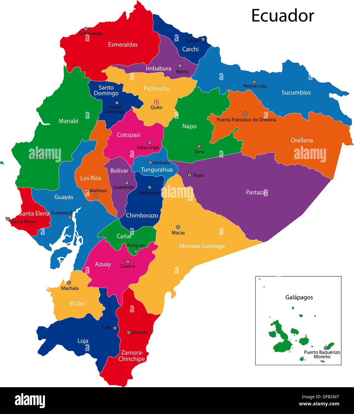
Ecuador’s Neighbors
Tucked away in the top-left corner of South America, Ecuador rubs elbows with two neighboring countries and gazes out over the Pacific. These geographic connections are pretty important in shaping its politics and economy.
Colombia: North Buddy
Ecuador and Colombia share a friendship that spans 708 km to the north. We’re talking a mix of towering Andes and lush rainforests here, a bumpy ride for sure! Trade and security teamwork are in full swing, with Ecuador and Colombia pulling together in regional get-togethers. If you’re itching for more neighborly chit-chat, check out the scoop on Colombia’s neighbors.
| Country | Border Length (km) |
|---|---|
| Colombia | 708 |
Peru: Down South and East
On the east and south sides, Ecuador and Peru have a whopping 1,529 km border. Mountains? Check. Rainforests? Double-check. This connection is super important for trade since Peru is a top spot for Ecuador’s exports. Sure, they’ve had some spats over the borders in the past, but now they’re all about shaking hands and making deals. For a peek at Peru’s neighbors, wander over to Peru’s side of things.
| Country | Border Length (km) |
|---|---|
| Peru | 1,529 |
Pacific Ocean: The Big Blue Buddy
The Pacific Ocean hugs Ecuador’s west side, stretching a massive 2,237 km of sunny coastlines. This area is a hotspot for everything ocean-related, from catching fish, shipping goods, to drawing in tourists. Being near the ocean also means that Ecuador is part of the Pacific Ring of Fire, facing all sorts of interesting geological stuff like quakes and volcanoes rumbling now and then.
Got a taste for more global neighbor gossip? Check out rundowns on Germany’s neighbors, India’s nearby pals, and Greece’s adjacent countries.
Geography and Landscapes
Ecuador is like a treasure chest filled with amazing places, from sunny shores to towering mountains and the wild Amazon rainforest. Each corner offers something special for those who venture in.
From Coastal Deserts to Andean Peaks
The variety in Ecuador’s landscapes is truly remarkable, as seen in its coast and mountains. The Costa region stretches from the Pacific Ocean all the way to where the Andes start. Here you’ll encounter small hills, sandy deserts, lush plains, and forests. It’s like a bag of mixed goodies for the eyes!
Heading inland, the Sierra region stands tall with not one but two mountain chains. Some peaks even kiss the clouds! There’s Cayambe standing at a staggering 18,996 feet, Cotopaxi—an active volcano—shouting at 19,347 feet, and Chimborazo, the top dog at 20,702 feet. These heights create an incredible mix of climates and natural wonders all over Ecuador.
| Region | Special Traits | Tallest Spot (Feet) |
|---|---|---|
| Costa | Hills, deserts, lush plains, forests | Up to 2,600 |
| Sierra | Majestic peaks, fiery volcano | Up to 20,702 (Chimborazo) |
The Richness of the Amazon Basin
Over in eastern Ecuador, the Amazon Basin hums with life—an absolute haven for nature lovers. The rainforests here are bursting with life, with plants and animals that you won’t find anywhere else. It’s a key player in keeping the planet’s weather in check, too.
The Amazon is also a cultural hotspot, home to indigenous tribes who live in tune with nature, adding layers to Ecuador’s rich culture. With its dense jungles and snaking rivers, it’s like Disneyland for eco-tourists and scientists wanting a peek at its wonders.
| Aspect | What’s Special |
|---|---|
| Critter Paradise | Many plants and animals unique here |
| Cultural Tapestry | Home to many indigenous tribes |
The Enigmatic Galápagos Islands
Sitting about 600 miles from Ecuador’s shores in the Pacific, the Galápagos Islands are famous for showing Darwin the way to evolution. These volcanic isles host creatures like giant tortoises, marine iguanas, and birds that just don’t live anywhere else.
For animal fans and scientists, the Galápagos are like a dream come true. Strict conservation rules keep the islands pristine for future generations and allow continued studies in evolution and nature. Visitors from all over the globe come to see their wonders.
| Island Group | Highlights |
|---|---|
| Galápagos Islands | Unique creatures, volcanic scenes, science |
Explore more on the natural beauty and setups of other countries through our articles on neighboring countries of the Dominican Republic and Ethiopia’s neighboring countries.
Transport and Connectivity
Getting around Ecuador and its neighbors like Colombia, Peru, and the open waters of the Pacific is a puzzle many travelers face, so let’s chat about what you can expect when moving from point A to point B. We’ll dive into plane costs and what the network of buses looks like for those trekking across cities in Ecuador.
Air Travel Costs and Limitations
Flying in Ecuador? Brace yourself, it’s not the cheapest. Compared to its neighbors, Ecuador’s sky-high taxes and airfare can leave wallets feeling lighter, whether you’re a local or just passing through. Those traveling domestically have to dig deep into their pockets (Lonely Planet). Here’s a snapshot of what you might spend getting from one major city to another:
| Route | Average Cost (USD) |
|---|---|
| Quito to Guayaquil | $120 |
| Quito to Cuenca | $110 |
| Guayaquil to Cuenca | $100 |
Even with the price tags, planes remain a quick way to jump between cities and reach far-flung spots like the Galápagos Islands.
Bus Networks and Intracity Transport
Buses offer a wallet-friendly alternative if you have time to burn and a sense of adventure. Long-hauls—say, from Huaquillas at the Peru border to Carchi by Colombia—can stretch 15 hours and cost between $25 and $30 (Lonely Planet). Short spins around town start as low as $3.
| Route | Duration | Cost (USD) |
|---|---|---|
| Huaquillas to Carchi | 15 hours | $25 – $30 |
| Quito to Guayaquil | 8 hours | $10 – $12 |
| Quito to Cuenca | 10 hours | $12 – $15 |
Moving around within cities? Pack some patience. Urban buses can be tricky, with unpredictable schedules and multiple hops needed to hit your target. Still, it’s a cheap ride, from $0.35 to $1 depending on where you’re going (Lonely Planet).
For ways to master Ecuador’s bus systems, safety tips, and some of the top routes, peek at our article on tips for straightening curly hair.
When you get the lay of the land, mapping out your adventures across Ecuador becomes a less bumpy ride—from busy city streets to the heart of the wilderness. Interested in more about Ecuador’s links to its neighbors? Check out our guides on Guatemala neighboring countries and Guyana neighboring countries.
Economic and Trade Relationships
To grasp Ecuador’s current status and its lofty aims in the world, looking at its economy and overseas trade ties is the way to go. This South American country is busy exporting, importing, enhancing its electrical setups, and pulling stuff out of the ground to fuel its economy.
Major Export and Import Partners
Ecuador’s all into swapping goods with a bunch of other nations, which is like the heartbeat of its wealth. Who does Ecuador ship its cherished goods to, you ask? The United States, Peru, China, Chile, and Panama eat it up. And when it needs to bring in stuff, the U.S., China, Colombia, Panama, and Brazil are there with open arms (Britannica).
| Trade Partners | Exports (Main Destinations) | Imports (Main Sources) |
|---|---|---|
| United States | ✅ | ✅ |
| Peru | ✅ | ❌ |
| China | ✅ | ✅ |
| Chile | ✅ | ❌ |
| Panama | ✅ | ✅ |
| Colombia | ❌ | ✅ |
| Brazil | ❌ | ✅ |
Strengthening Electricity Infrastructure
Ecuador isn’t sitting back when it comes to powering up its electricity game. In 2022, the nation saw power demand on the SNI grid peak at a hefty 4,388 MW. To keep up with this ever-growing thirst for juice, plans are on the table to crank out an extra 6,300 MW between 2023 and 2032, with a lot of love for renewable energy (Wikipedia).
This juicing up of the grid is make-or-break to keep the economic wheels turning and making sure folks and factories alike don’t end up in the dark. Plus, a beefed-up electrical grid opens doors for exchanging green energy with neighbors, making for a more hooked-up regional power community.
Resource Production and Economic Growth
Ecuador’s no slouch when it comes to churning out significant crops. Bananas, cocoa, and palm oil? They’ve got it covered, placing among the top ten global producers of these staples:
- In 2018, the banana harvest clocked in at a whopping 6.5 million tons.
- Cocoa hit 235 thousand tons.
- And palm oil squeezed out a solid 2.7 million tons (Wikipedia).
| Resource | Production (2018) |
|---|---|
| Bananas | 6.5 million tons |
| Cocoa | 235 thousand tons |
| Palm Oil | 2.7 million tons |
From 2000 to 2006, Ecuador’s economy threw down a mean growth rate of 4.6% per year, doubling up its GDP by 2007 to hit a cool 65,490 million bucks (Wikipedia). While it faced bumps in the road with trade imbalances every now and then, on the whole, the numbers are trending up, with more growth expected to unfold.
If you’re curious about how Ecuador stacks up against its neighbors or are just nosy about Germany or Guyana’s border friendships, check out our articles on Germany’s neighboring countries and Guyana’s neighboring countries.
Historical Border Conflicts
Ecuador’s history is a bit of a tangled mess of border tussles, with its edges reshaped by squabbles and treaties involving places like Colombia and Peru. Let’s take a walk down this rocky road.
Gran Colombia and Territorial Disputes
In 1819, Simón Bolívar, often depicted with a dashing mustache and a twinkle of ambition in his eye, gathered up Colombia, Ecuador, Venezuela, and Panama into a mega-entity called Gran Colombia. This supergroup drew its lines based on how the Spanish had divvied up the territory in 1809, thanks to some old-school principle called uti possidetis juris. By 1830, Gran Colombia decided to break up the band, sparking arguments over who owned what.
Enter the Pedemonte-Mosquera Protocol in 1830, which attempted to settle the squabbles by sketching borders from the Andes to Brazil, hugging the Marañón and Amazon Rivers. But the pesky little area of Jaén de Bracamoros just couldn’t stay out of the drama. It was a bit like that one sock you always lose in the wash—endlessly elusive.
Rio de Janeiro Protocol
Skip forward to January 29, 1942. Ecuador and Peru, irritated by ongoing disagreements, decided it might be a good idea to make nice under the Rio de Janeiro Protocol. Foreign ministers from both sides shook hands and, with a little help from their friends—the United States, Brazil, Argentina, and Chile—brokered a temporary peace to wrap up the Ecuadorian-Peruvian War. This set some borders straight, or so they hoped.
But defining these lines was easier said than done. The exact cuts on the map stayed a bit foggy until 1999, leaving plenty of room for more disagreements.
Cenepa War and Peace Agreements
In 1995, the Cenepa War exploded, as Ecuador and Peru took to the field over territories left ambiguous by the Rio Protocol. This showdown, gripping though it was, shouted the need for finality.
Cue the Brasilia Presidential Act in 1998, ushered in by the same powerhouses from the 1942 talks. This time, they meant business, signing a peace deal that promised to shut the border conflicts down for good. The ink on the map was completed in 1999, finally cementing peace and a friendly handshake between Ecuador and Peru.
Peeking into these historical tidbits gives a clearer picture of Ecuador’s rollercoaster ride to define its borders. It’s a spicy tale of ambition, negotiations, and eventual harmony in the tangle of a map. To explore more entanglements, click around for gossip on Dominican Republic’s neighbors and Ecuador’s nearby pals.
Tourist Destinations and Attractions
Ecuador, with its mix of landscapes, is like a treasure chest for tourists. From northern cloud forests to sun-kissed beaches in the south, not forgetting the mysterious Amazon, there’s a slice of adventure for every curious mind.
Northern Cloud Forests and Mangrove Swamps
Up in the north, Ecuador flaunts its mystical cloud forests and mangrove swamps. Cloud forests, places like Mindo, are famous for their mind-boggling range of plants and animals, with birds and orchids taking center stage. It’s a birder’s paradise and a playground for hikers wanting to soak up nature.
The mangrove swamps, like the ones at Manglares Churute Reserve, offer a totally different vibe but are just as enchanting. They’re packed with a jumble of unique plants and critters that make any nature lover’s heart skip a beat.
Southern Coast and Surfing Hotspots
Down south, the coast becomes a magnet for surfers, tourists, and adventure seekers. Places like Guayaquil, Montañita, and Salinas buzz with energy thanks to their beautiful beaches and lively atmosphere (Rough Guides).
Must-see spots:
- Manglares Churute Reserve
- Hilltop village of Zaruma
- Petrified forest of Puyango
These places serve up a cocktail of thrill, history, and natural charm.
Eastern Amazonian Rainforests and Biodiversity
In the east, the area known as the Oriente, stretches a whopping 186 miles of the Amazon rainforest. It’s a wildlife wonderland with places like Cuyabeno Wildlife Reserve and Yasuní National Park busting with life (Rough Guides).
| Protected Area | Highlights |
|---|---|
| Cuyabeno Wildlife Reserve | Packed with wild critters, jungle treks, meet indigenous folks |
| Yasuní National Park | Rich in species, cozy rainforest lodges, ecological marvel |
Visitors to Oriente can chill in jungle lodges, mixing the comforts of home with the raw wildness of the Amazon. For more adventures, why not pop over to neighboring Peru or Colombia? They’re just a hop away.
Whether you’re looking to unwind in the cloud-kissed forests, ride the wave on the southern shore, or get lost in Amazon’s dense embrace, Ecuador has it all. To widen your travel horizons, peek at global spots like the Dominican Republic or Egypt. Adventure awaits just around the corner!

