Brazil Neighbouring Countries on the Map
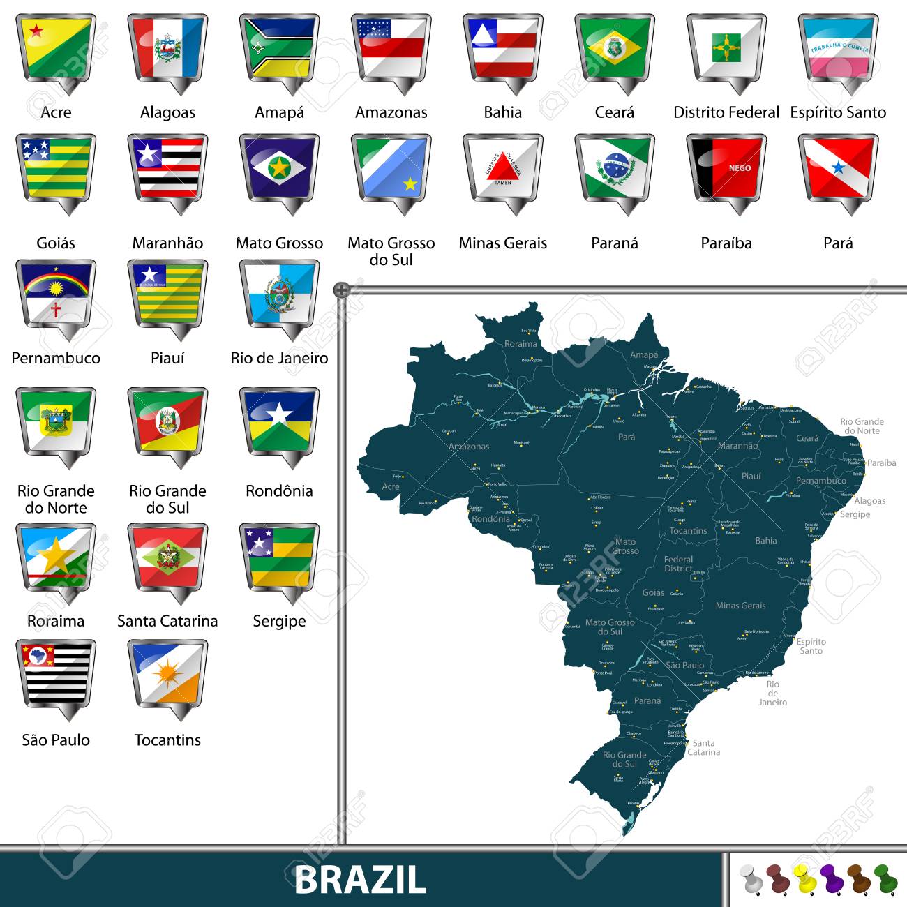
Brazil’s Neighbors Overview
Brazil, the land of samba and soccer, isn’t just known for its vibrant culture and festivities. It’s also a massive slab of land stretching across South America, touching borders with nearly every other country on the continent. If you’re nosy about Brazil’s neighborhood dynamics, you’re in the right place!
South American Borders
With a jigsaw puzzle-like border spanning around 16,885 kilometers (or about 10,492 miles if that’s more your style), Brazil cozies up to nine neighbors in South America, along with an overseas guest, the French Department of Guiana. Check out the lineup of Brazil’s next-door neighbors and how much elbow room they share:
| Neighboring Country | Border Length (km) |
|---|---|
| Argentina | 1,263.4 |
| Bolivia | 3,423 |
| Colombia | 1,644 |
| Guyana | 1,308 |
| Paraguay | 1,365 |
| Peru | 2,995 |
| Suriname | 593 |
| Uruguay | 1,068 |
| Venezuela | 2,200 |
Data from (Britannica)
This web of borders makes Brazil a big deal, both geographically and politically, in South America. For those keeping score, unlike its pals in politics, Brazil doesn’t rub shoulders with Chile and Ecuador, but it has plenty of beachy real estate with a coastline measuring 7,491 km that snuggles up to the Atlantic Ocean.
The French Department of Guiana
Peeking over from Europe, the French Department of Guiana (more casually called French Guiana) stands out in Brazil’s crowd of neighbors. This overseas slice of baguette land’s settled on the northern part of the continent. Its frontier with Brazil stretches a cozy 730 kilometers (454 miles) and waltzes along the Oyapock River, injecting a dash of European flair into the mix. French Guiana’s presence is like having a slightly exotic, culturally rich cousin who somehow fits right into family gatherings.
So there you have it, a virtual tour of Brazil’s bustling border scene. These neighbors form a dynamic mix that shapes Brazil’s role in the region, with each offering unique vibes and stories. Check out more boundary tales in our series, such as Angola’s neighboring countries and Argentina’s neighboring countries.
Brazil’s Border Magic
Brazil’s Biggest Neighbor Hug
Brazil, the colossal titan of South America, cozies up to Bolivia with a hug that spans 3,423 kilometers. This long squiggle across the map shows off just how big Brazil really is. But wait, glance over at the Atlantic Ocean, and you’ll see Brazil wink with an even longer smile—its coast stretches a mind-blowing 7,491 kilometers.
| Country | Border Length (km) |
|---|---|
| Bolivia | 3,423 |
| Argentina | 1,261 |
| Colombia | 1,644 |
| Peru | 2,995 |
| Guyana | 1,606 |
| Venezuela | 2,200 |
| Paraguay | 1,371 |
| Uruguay | 1,068 |
| Suriname | 593 |
| French Guiana | 730 |
Waterfall Wonders on the Edge
Across Brazil’s borders, nature puts on a show with waterfalls that have tourists and adventurers ooh-ing and aah-ing. Star of the show: Iguazu Falls struts its stuff at the Argentina line. Imagine 275 waterfalls performing together, and you start to get the picture. Over on the Brazil-Guyana scene, the Orinduik Falls paints a pretty picture with water gracefully slipping over colorful rocks.
The saga of Guaíra Falls is a tinge tragic. Once a waterfall diva along Paraguay’s border, it was swept away beneath the waves by Itaipu Dam’s construction in 1982 (Wikipedia).
Where Three Become One
Brazil’s borders play host to some quirky corners where three countries come together in what we call tripoints. There’s a gang of nine of these hangout spots, where Brazil high-fives its neighbors. These meeting points just show how Brazil nestles into the heart of South America.
Checking out these border works of art paints a picture of Brazil’s massive stretch of land and the ties it shares with its neighbors. Fancy more neighborly tales? Skip on over to read about Argentina’s neighbors and Bolivia’s neighbors.
Country-Specific Borders
Argentina and Uruguay
Brazil’s got a pretty lively stretch along its frontier with Argentina and Uruguay. This line’s infamous for the jaw-dropping Iguazu Falls sitting pretty on the Iguazu River. Imagine Niagara, but wearing South American flair (Wikipedia on Brazil’s Borders).
| Country | Border Length (km) | Notable Features |
|---|---|---|
| Argentina | 1,261 | Iguazu Falls |
| Uruguay | 1,069 | watery part 749 km, dry land 320 km |
Hop over to Uruguay and you’ll find Brazil’s border cruising along for 1,069 kilometers, splitting nicely into 320 kilometers on land while the rest, 749 kilometers, drifts through waters (Taylor Francis). This water bonanza’s a big shot for trade and Mother Nature’s balance.
Paraguay and Bolivia
The Paraguayan line stretches about 848.17 miles, chucking in gems like the International Peace Bridge. This border wave was born post the rip-roaring Paraguayan War of 1864. Guaíra Falls made a splashy appearance till 1982 when the Itaipu Dam decided it preferred the land under water.
| Country | Border Length (miles) | Notable Features |
|---|---|---|
| Paraguay | 848.17 | International Peace Bridge |
| Bolivia | 2,126.95 | Dust-up over Acre, Treaty of Petropolis 1903 |
Bolivia boasts the longest arms with Brazil, spreading 2,126.95 miles (World Atlas). These lands saw a heated tango over Acre, not settling down till the Treaty of Petropolis in 1903.
Peru and Colombia
Rolling onto the west side, Brazil hugs Peru and Colombia while high-fiving the Amazon Rainforest. It’s no secret—the Amazon’s a superstar in the conservation game.
| Country | Border Length (miles) | Notable Features |
|---|---|---|
| Peru | 1,068 | Amazon Rainforest |
| Colombia | 1,021 | Amazon Rainforest |
Peru and Brazil take it long-distance at 1,068 miles, while the Colombia bromance cuts a dashing 1,021 miles. Both borders play dress-up with the Amazon Rainforest, flexing its might over natural and cultural gigs in the area.
Peeking into Brazil’s borders opens a smorgasbord of history and geography shaping its heart and soul. Sneak a look at Colombia neighbouring countries and Paraguay neighbouring countries for more about how Brazil’s buddies get along.
Historical Border Disputes
Disputes with Bolivia
Brazil and Bolivia go way back, and not always on the best terms, especially when it comes to their borders. Stretching over a pretty lengthy 2,126.95 miles, the line between them hasn’t always been clear-cut. Most of the drama happened over Acre, a land dripping with rubber and other goodies. This juicy piece of earth had both countries butting heads, even pulling out the big guns at one point—literally. Tensions skyrocketed until it became a biggie back in the early 1900s, making both sides sit up and finally take notice.
Treaty of Petropolis (1903)
All that fuss over Acre didn’t go unnoticed and eventually brought both countries to the negotiating table, resulting in the Treaty of Petropolis in 1903. This was a game-changer for South America back then. In simple terms, Brazil ended up with Acre, while Bolivia got a nice check for $2 million and a slice of Brazilian land to better access the Madeira River—crucial for moving their goods around.
Part of the deal was to build a railway—the Madeira-Mamoré Railway, to be exact. This wasn’t just a line of tracks but a lifeline for Bolivia, opening doors to international markets and boosting their economy. So, the Treaty of Petropolis not only put the brakes on a serious border showdown but also laid the groundwork for these two neighbors to work together down the road.
Keen to know more about Brazil’s boundary stories and past deals? Check out our takes on Argentina’s neighbors and Colombia’s frontier tales.
| Chew on This | Treaty of Petropolis (1903) |
|---|---|
| Land Swap | Acre goes to Brazil |
| Cash Exchange | $2 million to Bolivia |
| Bonus Clause | Build the Madeira-Mamoré Railway |
Digging into these past border tiffs sheds light on how things stand today between Brazil and its borders. Curious about the present-day shuffle? Skim through our deep dive into Brazil’s geopolitical ties with its neighbors.
Recent Border Developments
Agreements with Paraguay
Brazil and Paraguay share a pretty long border, and they’ve had their ups and downs. Back in 2009, the two shook hands on a deal that put to rest an ongoing squabble over how much coin each should pay for the energy they get from the Itaipu hydroelectric plant, right on their boundary. This deal opened the door for more teamwork between them, smoothing the way for some exciting plans down the line.
Here’s a quick look at what went down:
| Year | Agreement Detail | Impact |
|---|---|---|
| 2009 | Settled Itaipu Plant Energy Costs | Better relations and money-making collabs |
If you’re thirsty for more info, check out our article on bolivia neighbouring countries.
Infrastructure Projects with Neighbors
Brazil’s been busy building stuff lately, all to get chummy with the neighbors. A biggie was the go-ahead in 2010 for a huge hydroelectric dam in the Amazon. It’s set to be the third-largest on planet Earth, aiming to zap those energy problems and keep Mother Nature happy (BBC).
Another milestone in 2011 was Brazil getting a road to run from its eastern coast clear over to Peru’s west coast, making trades easier and getting folks in the communal spirit (BBC). This move cranked up trade vibes and made getting from A to B a breeze.
Check out the standout projects in Brazil’s backyard:
| Year | Project | Neighboring Country | Objective |
|---|---|---|---|
| 2010 | Big Amazon Dam | Several Neighbors | Sort out energy issues |
| 2011 | Coast-to-Coast Road | Peru | Pump up trade |
These projects show Brazil’s serious about palling around with neighbors, hoping to beef up both money and diplomatic ties. Get more scoop on Brazil by visiting our articles on argentina neighboring countries and paraguay neighboring countries.
Geographical Features
Central-West and South Regions
In Brazil’s central-west, you’ve got Goiás, Mato Grosso, Mato Grosso do Sul, and the Federal District – that’s where Brasília, the capital, sets up shop. This part of Brazil really shines with its big open spaces and a mix of terrains, playing a big role in farming and agriculture.
States in Central-West Region:
| State | Standout Features |
|---|---|
| Goiás | Home to Cerrado biome, farming hotspot |
| Mato Grosso | Famous for Pantanal wetlands, soybeans aplenty |
| Mato Grosso do Sul | More Pantanal, lots of cattle ranching |
| Federal District | Where Brasília, the political hub, is found |
Head south and you hit Paraná, Santa Catarina, and Rio Grande do Sul. These parts boast a mix of making things, growing things, and service-sector work (Britannica). About one-seventh of Brazilians call this region home, full of rich culture thanks to many European immigrants.
States in South Region:
| State | Standout Features |
|---|---|
| Paraná | Known for Iguaçu Falls, lots of coffee |
| Santa Catarina | Famous for its beaches and industry |
| Rio Grande do Sul | Porto Alegre’s the place; also known for its wine |
For those curious about how these states line up with neighboring countries, you can check out some quick links here: Argentina’s neighbors and Bolivia’s borders.
Amazon Rainforest in the North
Now, in Brazil’s north, we’re dealing with more than two-fifths of the country’s area, covered in the lush Amazon jungle (Britannica). It’s a massive chunk of green with tons of plants and animals, loads of rivers, and some pretty unique indigenous cultures. People are spaced out here, and while it’s a huge area, it doesn’t pack quite the punch economically as other regions do.
Features of the Amazon Rainforest Region:
| Feature | Description |
|---|---|
| Rainforest Coverage | It’s the biggest rainforest on the planet |
| Major Rivers | Includes the Amazon River and Rio Negro |
| Biodiversity | Teeming with thousands of living creatures |
| Landforms | Has the Guiana and Brazilian Highlands |
| Environmental Impact | Crucial role in keeping global climate in check |
If you fancy digging deeper into the interaction of this region with neighboring lands, here are more links to nibble on: Colombia’s borderlines and Peru’s perimeter.

