Paraguay Neighbouring Countries and South American Map
Paraguay’s Neighbors
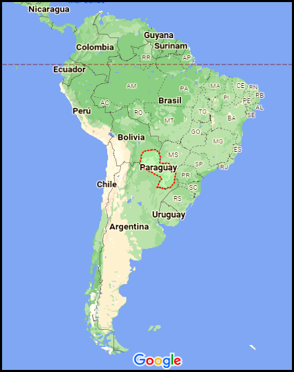
Tucked right in the middle of South America, Paraguay’s got itself snug between three pals: Argentina, Brazil, and Bolivia. This trio of neighbors is more than just a random cluster on a map; they define how Paraguay interacts with the outside world in terms of trade, politics, and cultural exchanges.
Geography of Paraguay
It’s like the heart of South America (minus the beaches), earning its spot by being smack dab in the center. But don’t let that “no beach” thing fool ya. Thanks to the Paraguay and Paraná rivers cutting through, it’s like a wet highway leading to the Atlantic, giving Paraguay a splash of trade access that keeps the wheels of its economy spinning.
Border Countries
Let’s break it down with some straight talk about its neighbors, who each bring their own flavor to the mix. They’re not just lines on a map; they’re Paraguay’s partners in the hustle of trade, economics, and a bit of history.
| Country | Border Length (miles) | Details |
|---|---|---|
| Argentina | 733 | These guys are like the southern watch, with borders tracing down the Paraná, Paraguay, and Pilcomayo rivers. It’s not just about fences here; it’s a water-border thing that ties their economies (WorldAtlas)). |
| Brazil | 801.5 | Over to the east and northeast, we’ve got Brazil. Famous for Samba and football, but their real game-changer here is the Itaipu Hydroelectric Dam on the Paraná River. They share more than just a border – they share the juice that runs the lights (WorldAtlas)). |
| Bolivia | 466 | Up northwest, it’s Bolivia. The two share more than just a border; once upon a time, they tangoed over territories like a couple of old-school cowboys during the Chaco War. |
Paraguay gets along well with these neighbors, more or less. They’re like that easy-going guy at a party who everybody knows. These borders do more than keep people apart; they open doors to ports, competitive trade opportunities, and tell tales from history’s pages, like the Chaco War. If you’re keen to pull at the threads of geography and politics in other lands, check out where Lithuania or Malaysia shuffle along with their neighbors in our articles Lithuania’s neighborly ties and Malaysia’s neighborly ties.
Argentina: Southern Neighbor
Border Length and Description
To the southern and southwestern stretch of Paraguay lies its lengthy neighbor, Argentina. These two nations share a line that runs about 733 miles, marking the longest international boundary for Paraguay with Argentina (World Atlas). This boundary isn’t just a zigzag on a map; it’s defined by the flow of three well-known rivers: the Paraná, Paraguay, and Pilcomayo.
| Border Attribute | Description |
|---|---|
| Total Length | 733 miles |
| Major Rivers | Paraná, Paraguay, Pilcomayo |
The westernmost point finds Paraguay meeting Argentina at the Hito I Esmeralda landmark, creating a divide with Argentina’s Boquerón department. These rivers do their job as natural borders but are absolutely essential for the hustling-bustling trade routes. They move goods with the rhythm of the water.
Relations and Historical Connections
There’s a thick book to write on the stories between Paraguay and Argentina. A chapter would surely feature the Paraguayan War, also known throughout the corridors of history as the War of the Triple Alliance. This battle, stretching from 1864 to 1870 with Argentina, Brazil, and Uruguay, was no polite disagreement; it reshaped a region.
Post-war, dotted lines turned solid with formal agreements in the late 1800s that firmed up the borders, hugging around the Paraná, Paraguay, and Pilcomayo rivers (World Atlas). In modern times, these countries aren’t distant neighbors passing each other in the hallway. They’ve built sturdy bridges in trade and politics. From food to machines, they’ve got a bit of everything on the move between them.
Their story is one of intertwining strands, showing how geography and politics often dance together in complex steps. Curious about more geographical and political ties in the area? Dive into our paraguay neighbouring countries overview.
And if you’re eager for more world stories involving neighboring pals, check out:
Brazil: Eastern Neighbor
Border Length and Description
Paraguay cozies up to Brazil for a border length of about 801.5 miles. Brazil certainly takes the cake as a significant partner for Paraguay, pressing along Paraguay’s east side. This border meanders through a mix of landscapes. One standout feature along this line is the mighty Itaipu Hydroelectric Dam, which straddles the Paraná River—this giant helps keep both Paraguay and Brazil powered up.
| Feature | Information |
|---|---|
| Border Length | 801.5 miles |
| Key Landmark | Itaipu Hydroelectric Dam |
| Important River | Paraná River |
Economic and Political Relationships
You can’t talk about Paraguay-Brazil ties without tipping your hat to the Itaipu Dam. It stands as the second biggest hydroelectric plant on the planet and churns out a ton of electricity. Paraguay ships a bunch of this power off to Brazil, which keeps the trade wheels greased between the two neighbors.
| Aspect | Description |
|---|---|
| Main Trade | Electricity from Itaipu Dam |
| Trade Influence | Major economic perk for both countries |
| Political Relationship | Cemented via joint hydroelectric projects |
Politically, working together on massive projects like Itaipu has smoothed the conversations between Paraguay and Brazil. Their teamwork not only handles the nuts and bolts of dam operations but also paves a way for tackling bigger regional issues together. This collaboration showcases how smart infrastructure can actually bolster a friendship between nations.
For those of you who want the full scoop on Paraguay’s geopolitical scene and folks next door, don’t miss the tales of Bolivia’s ties with Paraguay and stories of territorial disputes, which have weaved significant chapters in Paraguay’s narrative.
Bolivia: Northwestern Neighbor
Border Length and Description
Paraguay bumps into Bolivia to the northwest, sharing a border that stretches around 466 miles. This line slices through the Alto Paraguay department and spills into Bolivia. The land here is mostly rural, and you’ll find yourself wandering around the semi-dry area known as the Alto Chaco.
| Country | Border Length (miles) |
|---|---|
| Bolivia | 466 |
Expect flat, dry plains with not much green in sight, a complete flip from the lush, green-covered east of Paraguay. This stretch of land has seen its fair share of drama, with past territorial scraps between the two countries.
Chaco War and Territorial Disputes
Perhaps the most talked-about showdown between Paraguay and Bolivia was during the Chaco War, from 1932 to 1935 (Wikipedia). The scuffle was about grabbing control over the Chaco Boreal area, thought to be a goldmine of oil reserves. With oil companies playing cheerleader on each side, the battle raged on as the bloodiest on the continent in the 20th century.
Paraguay came out on top, snagging about 66% of the land up for grabs (World Atlas). Winning the war helped Paragauy secure a good chunk of its borders, pushing further west.
But the ink didn’t dry right away on peace papers. It wasn’t until 2009 that Paraguay and Bolivia sat down and really hammered out where their land started and ended, capping off 74 years of simmering tension.
The ripple effects of the Chaco War and what followed left a mark on how Paraguay’s map and politics shaped up. For a scoop on the nitty-gritty history of Paraguay’s tug-of-war over land, check out our in-depth piece on Paraguay’s Territorial Disputes.
Keeping an eye on these historical tales and maps helps get a grip on how complex the ties are with Paraguay’s neighbors. The border games with Bolivia, full of past clashes and eventual handshakes, paint a picture of Paraguay’s key spot in South America.
Paraguay’s Territorial Disputes
Paraguay’s story’s got a lot of bumpy roads, mostly due to those big fights over land. They had a massive face-off with Bolivia, known as the Chaco War, and an earlier dust-up with Argentina, Brazil, and Uruguay in what’s called the Triple Alliance War.
Chaco War with Bolivia
Back in 1932, things got heated between Paraguay and Bolivia, each itching to take hold of the Gran Chaco region. Why? Everyone thought the place was brimming with oil—a potential goldmine. This three-year standoff, ending in 1935, ended when a peace treaty handed Paraguay a big chunk of the land they wanted, swelling their control over the Chaco Boreal. Though the fighting left scars on both nations, Paraguay walked away with a prize—88,000 square kilometers added to its map.
| Country | Start of Conflict | End of Conflict | Land Area Gained by Paraguay (sq km) |
|---|---|---|---|
| Paraguay | 1932 | 1935 | 88,000 |
Triple Alliance War
Roll the clock back to 1864, and Paraguay’s knee-deep in another mess—the Triple Alliance War, a nasty affair with Argentina, Brazil, and Uruguay ganging up on ’em. It started after these neighbors inked a secret deal, stamping Bartolomé Mitre, Argentina’s top dog, as the big boss of their armies. The war raged until 1870, leaving a dismal wake of lost lives and land for Paraguay.
Come the war’s brutal end, Paraguay had to fork over vast swathes of real estate to Argentina and Brazil, shifting its borders significantly. This was no minor blip; the country bled away 157,000 square kilometers and a drastic population slice.
| Country | Start of Conflict | End of Conflict | Area Lost by Paraguay (sq km) |
|---|---|---|---|
| Paraguay | 1864 | 1870 | 157,000 |
These wars have etched permanent marks on Paraguay’s map and its dealings with nearby nations. To see how these epic chapters weave into today’s Paraguay and its boundary stories, check out bits on Mexico’s neighbors and Poland’s neighbors.
Paraguay’s Strategic Spot
No Long Walks to the Sea
Paraguay is stuck in the middle with Bolivia as its only buddy without a coast in South America. But hey, this hasn’t stopped it from hitting its stride both economically and strategically. It’s all thanks to a couple of river buddies—the Paraguay and Paraná. These water wonder-roads open the doors to trade and travel, saving Paraguay from feeling too boxed-in and leveling up its relationships with neighbors Brazil, Argentina, and Bolivia.
The Mighty River Highway
The Paraná-Paraguay Waterway is like a lifeline for Paraguay, connecting it to the vast Atlantic Ocean. This route brings Paraguayan soybeans front and center on the world stage, letting the country shake off those landboxed shackles.
| Key Tidbits | Stuff You Should Know |
|---|---|
| Rivers | The stunning Paraguay River, the mighty Paraná River |
| Ocean Pathway | Atlantic Ocean, here we come! |
| Main Water Cargo | Soybeans – loads of ‘em! |
Right on the banks of Paraná sits the Itaipu Dam, which literally powers up Paraguay’s economy to the next level. This beast of a power plant is second in the world for biggest hydroelectric networks, making energy so plentiful that Paraguay can sell the extra juice to Brazil. It’s a win-win, shoring up ties between the two.
Why It Matters:
- Opens the floodgates to global trade
- Moves soybeans like nobody’s business
- Boosts economic hustle and infrastructures
It’s not just a watery road though—it’s a ticket for Paraguay to show off in South America. The ports on these rivers are like little magic portals helping Paraguay not just survive but thrive despite its landless state. Want to see how other countries handle life without coastlines? Check out what our pals in Malawi are up to at malawi neighbouring countries.
Getting why Paraguay is sitting pretty in its no-seacoast seat shows how clever navigation can work wonders. To peek at how others make their landlocked status work—yup, we’re looking at you, Mongolia—head over to mongolia neighbouring countries.

