Panama Neighbouring Countries and Central American Borders
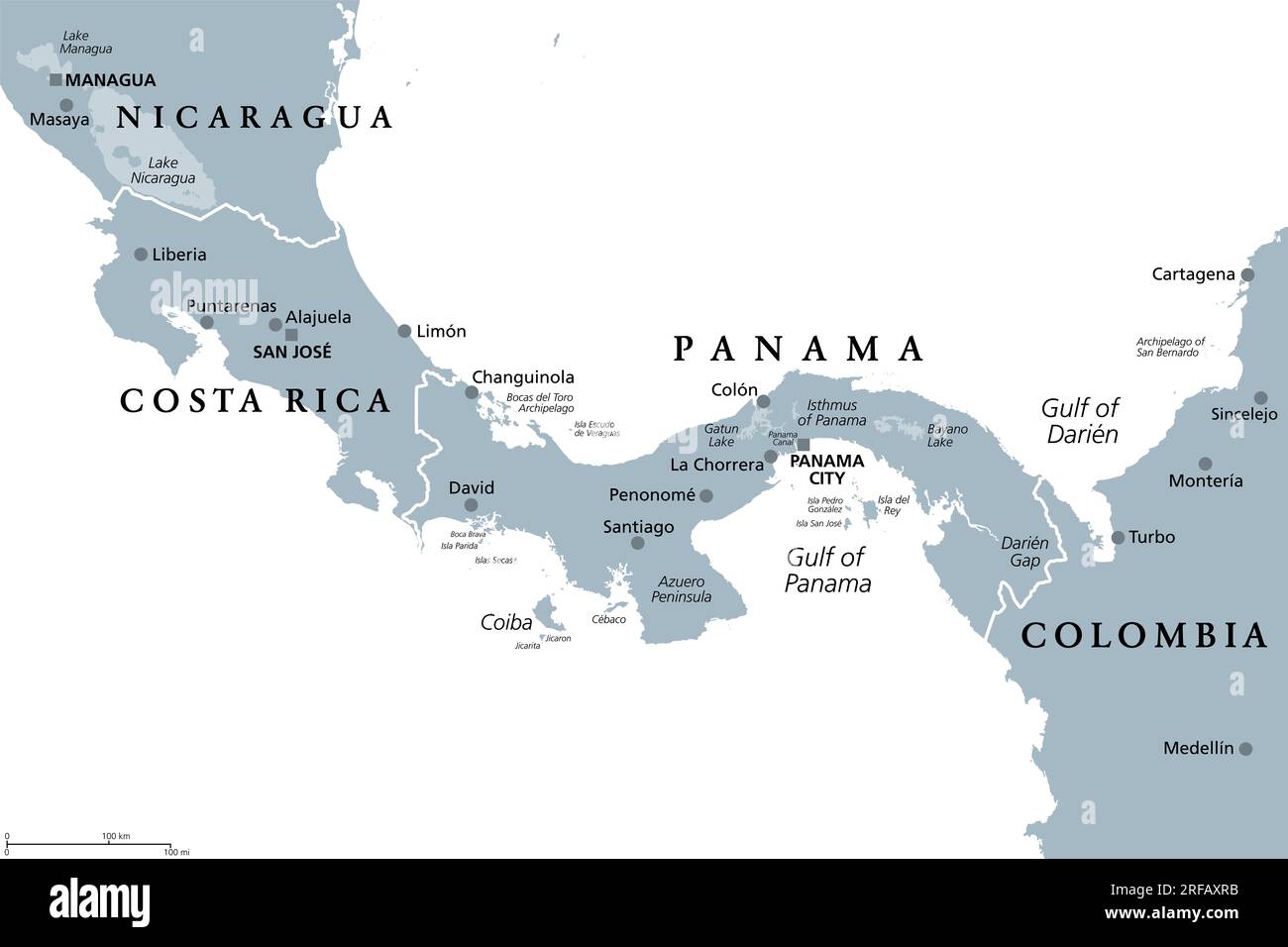
Panama’s Neighboring Countries
Panama sits in the heart of Central America, known for its prime spot on the world map and its varied terrain. It’s cozied up next to Costa Rica and Colombia, hugged by the Caribbean Sea up north and the Pacific Ocean down south.
Geography Overview
Imagine Panama like a friendly connector between mighty continents North and South America, thanks to its handy position. The Caribbean whispers to its northern shores and the Pacific roars to the south. Lean west and you’re bumping into Costa Rica, lean east and you’re saying hola to Colombia. Plus, the Panama Canal is kind of a big deal, moving loads of ships and trade through its famous water path.
| Border | Neighboring Country | Direction |
|---|---|---|
| West | Costa Rica | Northwest |
| East | Colombia | Southeast |
Bordering Costa Rica
Panama and Costa Rica? They’re like neighbors borrowing sugar, sharing a substantial boundary that helps in the merry dance of regional trade and transit.
| Border Characteristics | Description |
|---|---|
| Length of Border | 348 km |
| Major Border Crossings | Paso Canoas, Guabito-Sixaola |
| Primary Geographic Features | Mountains, Rivers, Tropical Forests |
The land between them sports all sorts of natural beauty, with mammoth mountains, bustling forests, and snaking rivers. Key spots like Paso Canoas and Guabito-Sixaola make it easier for people and goods to hop from one nation to the other.
Feeling adventurous? Check out our scoop on Mexico’s neighboring countries and Malaysia’s neighboring countries. If Panama-Costa Rica dynamics tickle your curiosity, more awaits you on shared boundaries and economic interactions.
Costa Rica’s Connection
Panama snugs up to Costa Rica on the west side, creating a cozy geographical and economical link. Here, we chat about their shared line in the sand and financial teamwork.
Shared Boundaries
Panama and Costa Rica have a border running about 330 km (or 205 miles) down Panama’s west side (Britannica’s got the scoop). This line kicks off at the Pacific Ocean, zigzags through the hills, and wraps up at the Caribbean Sea. It’s more than a land division—it’s a bridge connecting Central America with the world.
| Border Details | Data |
|---|---|
| Total Length | 330 km (205 miles) |
| West Start | Pacific Ocean |
| Trek Through | Mountains |
| East End | Caribbean Sea |
Economic Interactions
The economic dance between Panama and Costa Rica thrives along their shared boundary. They are busy trading partners. Sending back and forth everything from crops to gadgets to services (World Bank).
Apart from goods, there’s a bustling swirl of people cruising between the two for fun and work. Costa Rica rolls out the green carpet for tourists with its eco-appeal, pulling in folks from Panama. Meanwhile, Panama flaunts its prime spot as a world logistics center, luring Costa Rican companies to see what all the fuss is about.
Curious to know more about countries sharing their borders and what makes them tick? Peek into our article on Nicaragua’s neighboring countries. Or broaden your horizons with tales of Lithuania’s neighboring countries.
Bordering Colombia
Panama cozies up to Colombia at its southeast corner, creating a lively hub of exchange between the two amigos.
Southeast Connectivity
Panama and Colombia are like beans and rice—they’re different, but they really go together well. Fixed firmly in Central America, Panama rubs elbows with Colombia at its southeast end. This little piece of geography isn’t just about land; it’s a superhighway for all kinds of life—goods, services, even folks taking a stroll across borders, all bouncing back and forth boosting business and friendships.
| Connectivity Detail | Short Snapshot |
|---|---|
| Length of the Border | 225 km |
| Main Crossings | Darién Gap, Transport paths |
| Traded Goods | Handcrafted items, food stuff |
| Economic Hustle | Customs work, border business, goods flow |
Standing like a bouncer at a nightclub, the Darién Gap is this thick jungle hanging out at the Panama-Colombia line. It’s wild but opens secret doors—each twisty vine and muddy path a chance to improve roads and connect people.
Cultural Influences
The dance between Panamanian and Colombian culture is a sight to see. Both share that spicy Spanish flavor from way back when, and it pops up all over! The language, food, and fiesta spirit—it’s like a big family reunion with music and dance as the unspoken language of joy.
| Cultural Exchange | Notable Tidbits |
|---|---|
| Word Play | Spanish of course! |
| Tummy Treats | Twin delights – “Arepas” and “Sancocho” |
| Beat and Rhythm | Enjoy the Cumbia, Vallenato, and Salsa too! |
| Dance Groove | Afro-Caribbean sways, Colombian twirls |
The regions mixing it up on the border bring together a vibrant blend of old and new, where feasts and shindigs electrify the scene with shared tunes and tales, highlighting the bond of Panama and Colombia’s neighborhood love.
To get caught up in the swirl of Panama’s bond with Colombia brings to light a whole tapestry of regional hustle and heartbeats. Curious about how it all fits together? Dig deeper into tales of tight-knit neighbors like Lithuania’s neighboring hood or explore other Central American border stories.
Geographic Significance
Panama’s place on the map makes it a heavyweight in both its neighborhood and the larger scene. Sandwiched between the Caribbean Sea and the Pacific Ocean, it acts as a major player in the global trade game.
Caribbean and Pacific Borders
Drenched by the Caribbean on the north and kissed by the Pacific on the south, Panama’s location is no accident. The thinnest part of the country is just a hop, skip, and jump—30 miles wide. This narrow strip is gold for maritime routes.
- Caribbean Coastline: Spanning about 800 miles
- Pacific Coastline: Stretching roughly 1,060 miles
These long coastlines don’t just mean great beach days; they boost Panama’s role in trade and tourism while protecting a treasure trove of biodiversity.
International Trade Impact
Back when the Panama Canal was wrapped up by Uncle Sam in 1914, Panama went from “who’s that?” to “wow!” in the trade world, hooking the Atlantic and Pacific together.
- Canal Traffic: A never-ending parade of ships floats through each year, merging the world’s trade highways.
- Economic Contribution: With the canal pulling more than its weight, Panama’s economic engine fires up with help from the Colón Free Trade Zone (CFZ), the runner-up for biggest on the globe.
| Trade Zone | Key Facts |
|---|---|
| Colón Free Trade Zone (CFZ) | Home to over 2,500 companies, with 30,000 folks hustling, contributing to 8.5% of Panama’s GDP |
Panama keeps its business passport full, boasting 19 top-drawer free trade agreements worldwide. It’s a key player in the scramble of international trade.
For more know-how on nearby folks, check out pieces on nicaragua neighboring countries and mexico neighboring countries.
Historical Background
Peek into Panama’s past to see how its story’s woven with neighboring lands. Let’s roll back the years from Spanish invasions to Panama Canal’s construction.
Spanish Colonization
Back in the 1500s, Spanish wanderers set foot in Panama, claiming it as their own. It wasn’t just any colony – Panama was the grand entry to the Pacific. Later, it became the buzz spot for adventurers chasing Californian gold (Britannica). Fast forward to 1821, and Panama decides it’s had enough, breaking ties with Spain to join the club with Colombia, Ecuador, and Venezuela in forming the Republic of Gran Colombia. But things changed again in 1830; while the Republic split up, Panama stayed attached to Colombia (National Geographic Kids).
| Period | Key Events |
|---|---|
| 16th Century | Spanish exploration and settlement kicks off |
| 1821 | Parts ways with Spain, teams with Gran Colombia |
| 1830 | Sticks with Colombia post-Gran Colombia breakup |
Independence and Panama Canal
Panama’s bid for freedom got a boost in 1903, with the USA giving a nudge, and it bid goodbye to Colombia. They inked a deal to dig the Panama Canal, a game-changing shortcut for ships between the Atlantic and Pacific. From 1904 to 1914, the United States was busy with shovels and dynamite in tow (National Geographic Kids).
The canal’s reins were a hot topic. A 1977 handshake deal between Panama and the US meant Panama would eventually tote the canal’s financial bag (Oxford Research Encyclopedias). In 1999, Panama took the canal by the horns, marking a fresh chapter in its saga.
| Period | Key Events |
|---|---|
| 1903 | Panama breaks from Colombia, greenlights canal project |
| 1904-1914 | USA gets busy building the Panama Canal |
| 1977 | Treaty hands over canal profits to Panama |
| 1999 | Panama fully commands the Panama Canal |
Panama’s past isn’t just an echo; it’s the groundwork of its terrain and ties with the next-door nations. For the geographic scoop and neighborly connections, check out our pieces on lithuania neighboring countries and luxembourg neighboring countries.
Environmental Sustainability
Carbon-Negative Status
Ever give a round of applause to a whole country? Well, Panama’s earned it with their top-notch dedication to environmental sustainability, especially by grabbing that carbon-negative crown. This means Panama gobbles up more carbon dioxide than it lets loose, becoming a poster child for eco-friendly ambitions on a global scale. They’re hanging out in a cool kids’ club with Bhutan and Suriname, who also boast carbon-negative status. It’s like they’re saying, “Hey world, let’s give this climate change thing a proper run for its money!”
| Country | Carbon Status |
|---|---|
| Panama | Carbon-Negative |
| Bhutan | Carbon-Negative |
| Suriname | Carbon-Negative |
Curious minds might wanna see how their neighbors stack up in eco-chic maneuvers. So, go ahead and check out the green goodness in Costa Rica and Colombia.
Climate and Geography
Drop a pin on Panama, and you’ve hit a goldmine with its epic geographical spot that seriously shapes its environmental playbook. Sizzling temps and humidity are just day-to-day stuff there, with the sky throwing anywhere from 1,300 mm to a splash-tacular 3,000 mm of rain each year. Mostly during the rain parade from April to December, where the magical forests soak it all up. Panama’s making the most of it, with the lush greens loving every drop to capture more carbon.
| Climate Aspect | Description |
|---|---|
| Temperature | Roastin’ all year |
| Rainfall | 1,300 – 3,000 mm annually |
| Rainy Season | April to December |
Panama is a bit of a geographical patchwork quilt—think coastal plains, lumpy hills, and towering mountains. Each piece is bursting with biodiversity. This mix carries ecosystems as varied as a Saturday morning market, from jungles to splash zones. They’re pretty serious about saving all that goodness, which shows in their laws and heartfelt efforts from the folks on the ground focusing on eco-friendly growth.
Dying to see how Panama’s nature vibes mesh with the rest? Peep the Maldives neighboring countries or scoot over to the Marshall Islands neighboring countries for even more environment-minded inspiration.
Panama ain’t just another player on the climate stage— they’re a headline act, inspiring the neighborhood and the world to up the ante in the fight against climate change.
